

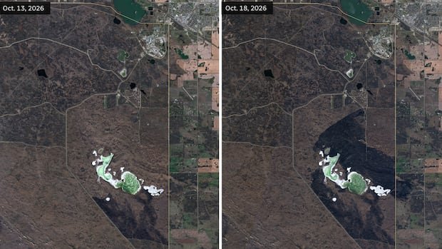

Satellite images captured the aftermath of a devastating fire that swept through part of CFB Wainwright in Alberta over the weekend, resulting in the tragic loss of four service members and leaving many others injured. The images, provided by Planet Labs, vividly display the extensive damage caused by the fire, which was exacerbated by dry conditions and strong winds. The fire danger index in the area had been classified as extreme by Natural Resources Canada, with a wind alert issued by Environment Canada on the morning of the incident.
The aerial images revealed a charred area spanning approximately 10 square kilometers on Sunday, just one day after the fire broke out. The specific location within the base where the fire originated is identified as a “permanent danger area” on OpenStreetMap, a widely utilized geographic database.
Local authorities reported on Sunday that the fire was under control, offering a glimmer of hope amidst the devastation. Maj.-Gen. Wade Rutland, commanding officer of the reinvigorated 1st Canadian Division, disclosed that the fire initially ignited as a grass fire and rapidly spread around 4 p.m. as the wind direction shifted. The incident occurred while soldiers were engaged in training exercises, including grenade throwing and a simulated enemy attack.
The community is mourning the loss of the fallen soldiers and rallying around those injured in the tragic event at CFB Wainwright.